The Republic of Lithuania Law on Energy from Renewable Sources stipulates that the Government of the Republic of Lithuania or its delegated authority – the Ministry of Energy of the Republic of Lithuania – shall organise the performance of marine surveys and other actions necessary for the development of wind power plants in the territorial waters of the Republic of Lithuania.
The public institution Lithuanian Energy Agency, in exercising the powers granted by the Ministry of Energy of the Republic of Lithuania, has assessed the need for mandatory marine surveys and The public institution Lithuanian Energy Agency, in fulfillment of the powers granted by the Ministry of Energy of the Republic of Lithuania, assessed the need for mandatory marine research and actions in the territory of the territorial sea of the Republic of Lithuania and/or the exclusive economic zone of the Republic of Lithuania in the Baltic Sea, where it is appropriate to organize a tender for the development and operation of power plants using renewable energy resources .development and operation of power plants using renewable energy sources is expedient.
After clarifying the need and preparing the necessary documents needed to organize the procurement of research and services, the public institution Lithuanian Energy Agency initiated international public procurement related to this project in order to identify service providers who will perform the planned research and services.
The development of wind power plants in the territorial waters of the Republic of Lithuania in the Baltic Sea is intrinsically linked to both the characteristics of the seabed and the geological structure of the subsurface. The seabed topography and its geological structure have a special impact on the selection of wind power plant construction and foundations, as well as the layout of the infrastructure.
In order to rationally plan the installation of a wind farm, all potential geological risks must be assessed, and any objects on the seabed, such as dangerous debris, unexploded ordnance and so on, must be analysed.
Taking this into account, complex geological and geophysical surveys of varying detail must be carried out in two stages, using complex engineering and geological research methods.
The Lithuanian Energy Agency has selected Geobaltic, UAB and Garant Diving, UAB as suppliers for geophysical surveys of the seabed through an international public procurement procedure. Representatives of the jointly contracted group of service providers presented the second seabed survey report. The report presents the results and conclusions of deep geophysical-seismic surveys in the Lithuanian offshore area, where it is appropriate to organise tenders for the development and operation of wind farms.
Deep geophysical and seismic surveys of the seabed in the Baltic Sea have confirmed that the area envisaged for the first offshore wind farm is suitable for the development of such activities.
Lithuanian Energy Agency has launched an international procurement for seabed survey services for the first wind farm in the Baltic Sea to connect to land. The procurement documents are available on the Central Public Procurement Portal.
The first stage included:
- investigation of the deep geological structure of the seabed: during this investigation, deep geophysical seismic surveys were carried out in order to identify potentially active seismic zones (geologically young tectonic faults crossing the entire sedimentary cover) and eliminate them from potential sites for the installation of offshore wind power plants. An assessment must also be conducted to confirm that the planned development of offshore wind farms does not overlap with the search for other strategic energy resources and possible mining in the territorial waters of Lithuania;
- investigation of the surface geological structure of the seabed: during this investigation, shallow geophysical seismic surveys were carried out, which are important for examining the geological structure of the seabed to a depth of 100 m from the seabed surface, since it is precisely this part of the seabed that is particularly important for the selection and installation of the offshore wind power plant foundations. The results of these surveys are also important for planning the scope of other surveys.
- investigation of the seabed surface morphology and distribution of surface sediments: during this investigation, hydrographic and geophysical surveys of the seabed surface were carried out to determine the features of the seabed topography and the composition and distribution of surface soils. In these surveys, special attention is given to determining the distribution zones of weak soils (in an engineering sense) and their thickness.
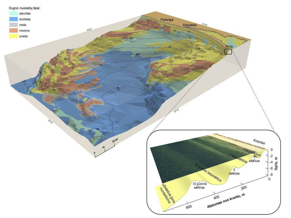
The second stage is planned to include:
- examination of the mechanical properties of soils: after carrying out the above and receiving their results, engineering geological and geotechnical studies are carried out, allowing to evaluate the mechanical properties of soils, which are extremely important for the installation of offshore wind power plant foundations. During these studies, based on the results of previous studies, vibro drilling, static probing and deep drilling will be performed, and laboratory tests of the lithological and mechanical properties of the extracted soil samples will be mandatory.
In the third phase, it is planned to assess the mechanical properties of seabed soils, which are important for the selection of offshore wind farm structures, cable construction and related infrastructure development.
The offshore wind farm connections to land geophysical seabed survey data
Engineering geology and geotechnical survey
Geophysical shallow seismics and hydrographic survey
Deep geophysical–seismic surveys
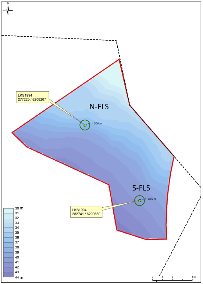
The Baltic Sea offers favourable conditions for the development of offshore wind farms, according to Spanish studies on wind speed and other hydrometeorological parameters. Spanish company EOLOS Floating Lidar Solutions SL has been carrying out a one-year study in the Lithuanian offshore area, where a 700 megawatt (MW) offshore wind farm is planned.
The economic efficiency of wind energy in the Baltic Sea also depends on favourable wind conditions at sea, which is why measurements of wind and other hydrometeorological parameters in the park area are crucial for assessing the wind potential and the capacity of the park's future power plants. For a potential park developer, this data will also help to select wind turbine models, calculate the required investment, model the layout and lifetime of the turbines and assess other important aspects.
The experts' analysis of the data confirmed that the annual wind capacity and other hydrometeorological parameters are in line with previously modelled estimates of the projected wind potential in the Baltic Sea. The results confirm that Lithuania has sufficient offshore wind resources and can successfully and efficiently develop offshore wind energy in the Baltic Sea.
Two buoys with specialised equipment were moored at two predefined locations in the Baltic Sea. Wind speed and direction were measured throughout the year at different altitudes from 10 to 280 metres. Atmospheric pressure, air temperature, relative humidity, wave height, current strength and direction and water level were also recorded.
The data analysis shows that the average wind speed at 100-200 m is between 9.0 and 9.6 m/s. The highest wind speeds were recorded during the cold season, in October and December-March (average 10-13 m/s), and the maximum average 10-minute wind speed over the whole measurement period at 150 m was 28.6 m/s.
The recorded higher winds during the cold season reaffirm the importance of offshore energy in the overall annual balance of electricity generation from renewable sources. It is during the cold season that the production of solar parks in Lithuania drops to its lowest level. Higher offshore wind speeds are a direct function of the amount of electricity generation and the more powerful turbine models chosen by developers.
Based on the available data, the prevailing wind direction in the area of the first offshore wind park was also assessed, which is important for the selection of the orientation of the wind turbines. Westerly and south-westerly winds were found to be more common.
Tender documents
The National Energy Regulatory Council (NERC) prepared the main winter tender documents for the offshore wind farms:
- Description of the Procedure for Organising Tenders and Issuing Permits.
- Description of the Requirements for Persons Who Seek to Acquire or Have Acquired the Right to Develop and Operate Power Plants Using Renewable Energy Sources in the Territorial Waters, and of Reimbursement for the Costs of Conducting Marine Surveys and Other Actions.
- Methodology for determining the maximum price and the reference price (Winter tender).
- The highest possible transaction price documentation (Winter tender).
COSTS REIMBURSED BY DEVELOPERS
The provisions of Articles 22 and 221 of the Law on Renewable Energy of the Republic of Lithuania (hereinafter referred to as RES) regulate the procedures for the use of renewable energy resources for the production of electricity in the offshore area and for the promotion of the use of these resources and their use without the application of incentive measures.
Please be informed that the successful tenderer referred to in Articles 22 and 221 of the RES Act must, within the prescribed time limit, fulfil its financial obligations by transferring them to a seperate account specified on the website ot the Minstry of Energy.
Information on the costs to be reimbursed to the winners of tenders organised on the basis of Articles 22 and 221 of the Renewable Energy Act
Pursuant to the Description of requirements for persons seeking and obtaining the right to develop and operate power plants using renewable energy resources in the maritime area and the procedure for reimbursement of the costs of surveys and other activities in the maritime area, approved by the Government on 19 October 2022. The Ministry of Energy has calculated the amount of compensation for the costs of carrying out the studies and other actions provided for in Article 22 of the Law on Renewable Energy to be reimbursed by the winners of the tenders announced on 30 March 2023 and planned to be announced on 15 January 2024.
The amounts of the compensation to be paid by the successful tenderers are set out in the link below
Preparatory works for offshore wind farm development and related infrastructure No. 03-004-P-0001

![]()
Market consultations
We aim to cooperate with tender participants of the offshore wind parks through market consultations.
If you have any questions or comments, please share them by e-mail: offshorewind@epsog.lt.
- Consultations with potential auction participants are organized regularly.
- The link to the meeting will be shared before the meeting.
- Answers to questions will be continuously updated in F.A.Q. section.
Presentation of Market Consultation held on the 10th of October 2023
Presentation of Market Consultation held on the 9th of February 2023
Presentation of Market Consultation held on the 15th of December 2022.
Presentation of Market Consultation held on the 10th of November 2022.
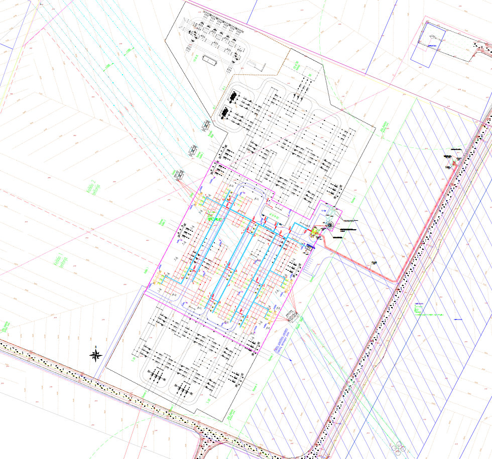
PRELIMINARY CONNECTION CONDITIONS
Darbėnai switchyard preliminary equipment plan
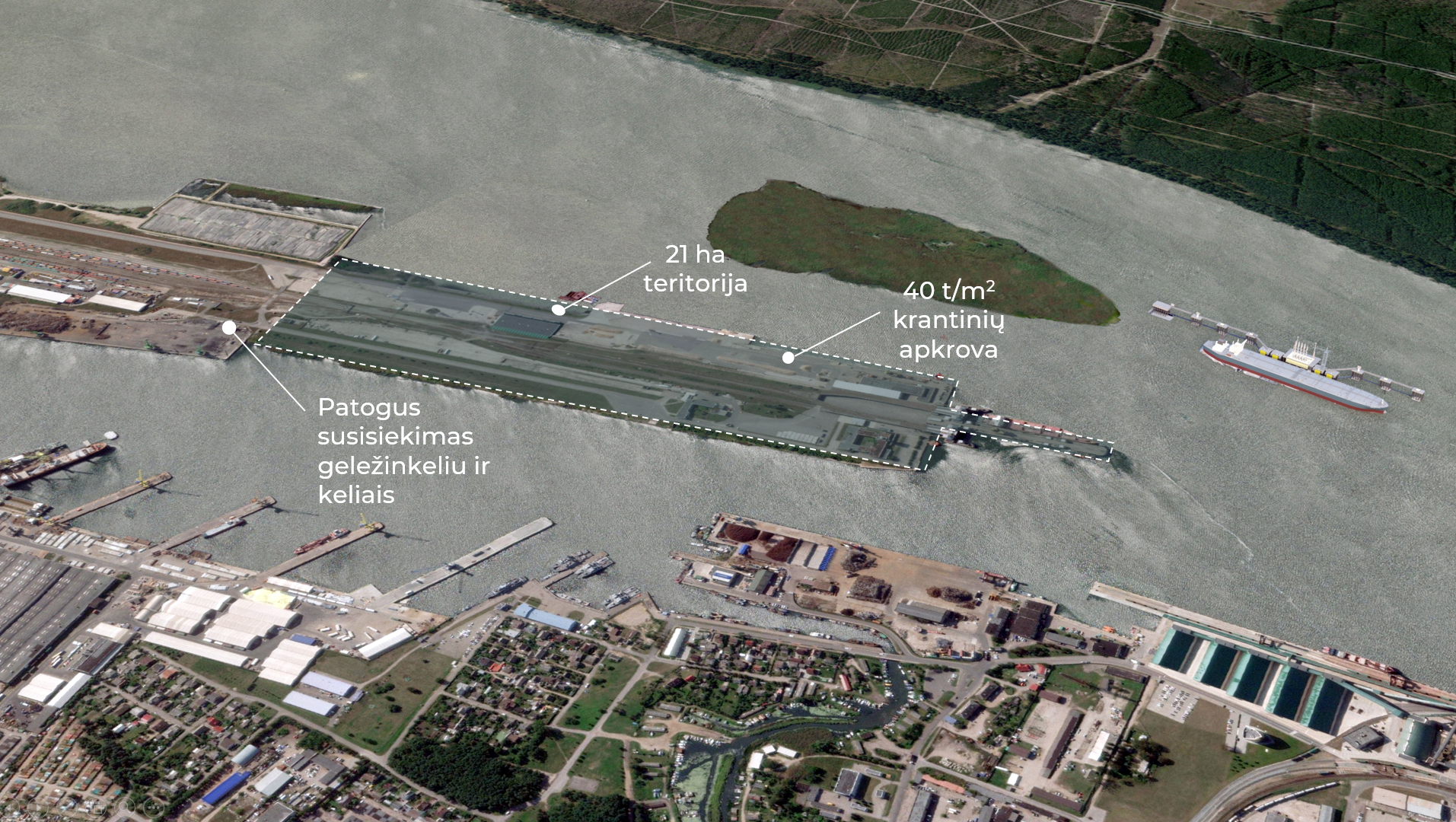
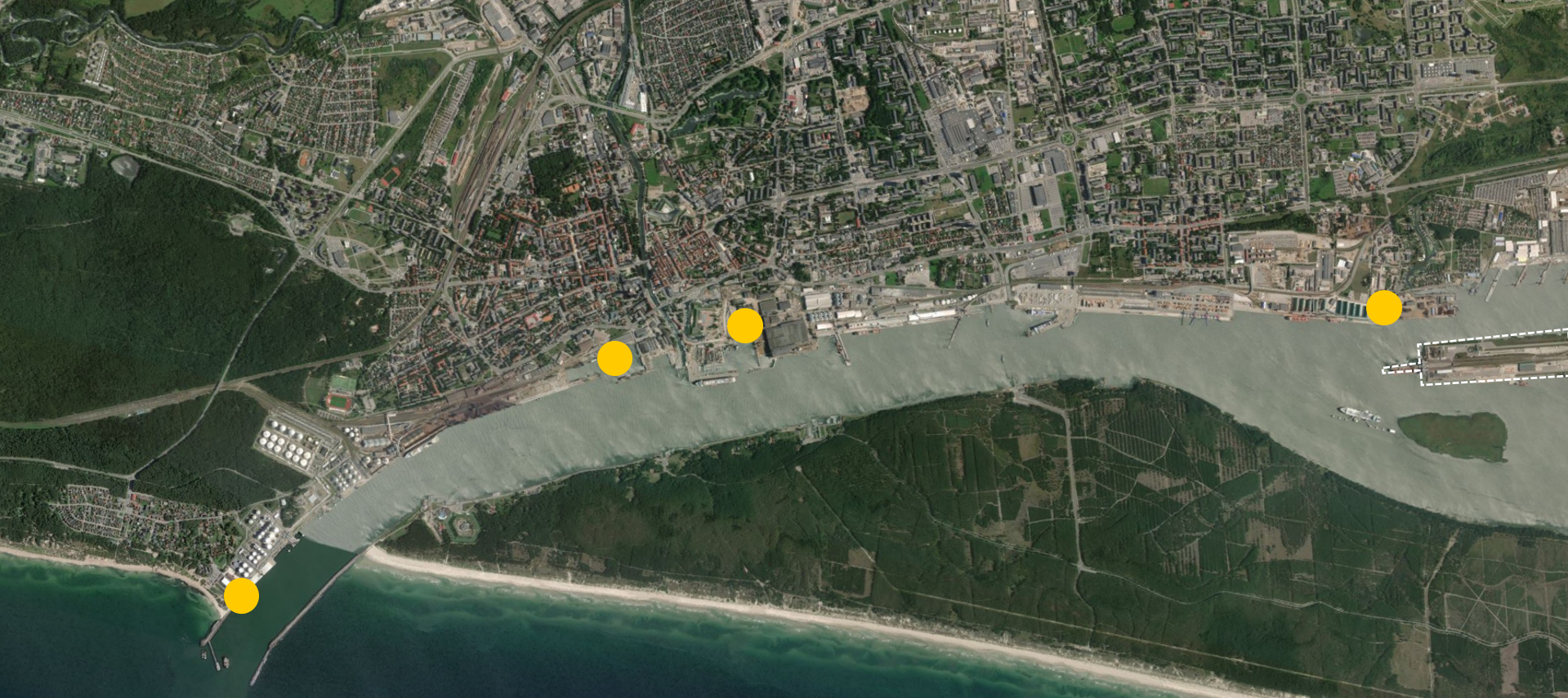
Klaipėda – Future Offshore Wind Hub
With favourable conditions for offshore wind development and numerous wind farm projects in progress, the Baltic Sea is becoming a hot spot for offshore wind industry development. To accommodate the growing demand for wind turbine pre-assembly, loading, and wind farm servicing, the Port of Klaipėda is building the necessary infrastructure. Offshore Wind Installation Port- 40 t/m2 quay load Up to 40 t/m2 quay load in parts of the quay for heavy lifting and in the rest of the area.
- Territory – 21 ha 21 hectares of territory for storage and pre-assembly of the wind turbines with convenient access by road and rail.
- Depth of 10-12 m The designed quay depth in the first stage is 10 meters. If needed, further dredging work could be done in the future.
 Offshore Wind O&M Hub
There are several options where an offshore wind operations and maintenance hub could be located. Currently, all the possibilities are being evaluated to pick the best location where maintenance ships would moor, offices, training centres and workshops could be located.
Offshore Wind O&M Hub
There are several options where an offshore wind operations and maintenance hub could be located. Currently, all the possibilities are being evaluated to pick the best location where maintenance ships would moor, offices, training centres and workshops could be located.
 Daugiau informacijos – Port Infrastructure for Offshore Wind